Overview
I chose this article as it relates to urban wildlife management in the context of urban planning and optimizing cities for wildlife diversity and connectivity. The study focuses on locally rare species representing a wide range of taxa, offering insights into how urban areas can be designed to support biodiversity through habitat corridors. The authors evaluated patterns of habitat availability and connectivity for nine rare species: two insects, three turtles, two snakes, one bird, and one bat across four urban regions in Michigan, USA. These species were selected because they are regionally rare (ranging from state-listed to federally endangered) but still maintain populations within urbanized landscapes. The study aims to identify how urbanization influences habitat structure, connectivity, and opportunities for conservation planning.
Methods
The researchers selected nine focal species representing several taxonomic groups known to be regionally rare. Species occurrence data were compiled from multiple reputable databases, including the Michigan Natural Heritage Database (MNFI), the U.S. Fish & Wildlife Service (USFWS), HerpMapper, iNaturalist, and eBird. To ensure data reliability, only verified MNFI and Research Grade iNaturalist records were used, and records prior to the year 2000 were excluded. Protected areas were mapped by merging all federal, state, county, local, and NGO-managed lands from MNFI GIS layers, excluding disturbed greenspaces such as golf courses.
Urban boundaries were defined using U.S. Census Bureau criteria areas with populations over 50,000 and a density of at least 1,000 people per square mile, with adjacent tracts of 500 people per square mile included as urban periphery. This classification allowed the researchers to analyze habitats embedded within realistic urban-to-rural gradients. Connectivity analyses were then conducted within selected urban regions that met these demographic criteria and contained overlapping species occurrences.
To establish biologically relevant study sites, the team generated 5 km buffers around each species occurrence, encompassing estimated dispersal ranges for most taxa. Overlapping buffers within 10 km of each other were merged, and convex hull polygons were created around the merged clusters. These polygons were then expanded by 5 km to define final analysis areas representing zones of multi-species co-occurrence. This ensured that the study captured both urban and adjacent non-urban habitats crucial for species movement.
Species distribution models (SDMs) were developed for each focal species using an “ensemble of small models” (ESM) approach, which performs well with limited occurrence data. Occurrence points were spatially thinned to a minimum spacing of 1 km to prevent overrepresentation of dense populations, with a target of at least 20 records per species. In cases of limited data, such as the American Bumble Bee, surrogate models were used (the Black and Gold Bumble Bee model).
Road networks were not included in the SDMs directly to avoid false habitat associations, but they were incorporated into resistance surfaces used for connectivity modeling. Roads were buffered by 30 m and assigned species-specific cost values to represent movement resistance: 1000 for reptiles (reflecting high road mortality), 500 for birds and bats (behavioral avoidance), and 250 for bees (potential roadside habitat but increased mortality risk). These road-cost rasters were then merged with each species’ SDM-based resistance surface.
Connectivity was evaluated using multiple tools. Circuitscape was applied to identify likely movement corridors and high-current areas representing multi-directional pathways, while Graphab was used to analyze habitat patch importance and network structure through the dPCk metric. Fragstats provided quantitative measures of landscape configuration, including connectance and clumpiness. Together, these tools revealed both broad and fine-scale patterns of connectivity and potential barriers for each species within and around the urban zones.
Results
Findings showed that many species retain moderate to high habitat proportions within urban landscapes, but the strongest connectivity corridors are typically located outside urban boundaries. Riparian and wetland zones were identified as critical linkages, especially for aquatic and semi-aquatic species such as turtles and snakes. Among the cities, Kalamazoo and Detroit North exhibited the most extensive multi-species connectivity networks, while Benton Harbor and Detroit Southwest showed more limited urban movement potential. Turtles had the highest habitat availability overall, suggesting persistent wetland and forest-edge habitats, whereas grassland species like Henslow’s Sparrow and bumble bees had the least. The study also emphasized that smaller, well-placed habitat patches often contribute more to overall connectivity than larger, isolated ones.
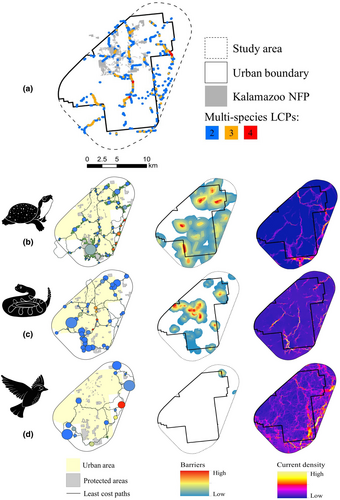
Fig. 3. Map of study area (a) showing Least Cost Paths (LCP’s), (From left to right) Protected areas, barriers impeding connectivity, and current species density.
Critiques & Reflection
This study effectively demonstrates how integrating multiple connectivity modeling tools can inform urban conservation planning. The inclusion of diverse taxa from reptiles to insects gives the findings broad ecological relevance. I found it particularly valuable how the authors linked quantitative spatial analysis to practical conservation implications, such as protecting riparian corridors and small but strategically located habitat patches.
The article does a great job of emphasizing the importance of riparian corridors and buffers, which in my opinion are not adequately regulated under today’s environmental laws. These areas are critical for maintaining ecological connectivity in urban regions, yet they are often overlooked in planning and development regulations.
Although the paper briefly mentions genetics, I believe this is an area that deserves greater focus. Genetic diversity and gene flow are essential components of wildlife corridor restoration, especially for populations that have become isolated by urbanization and experienced bottlenecking. Wildlife corridors are not only about providing safe passage between fragmented habitats, they also serve as vital habitat themselves, supporting long-term survival, breeding, and dispersal. Many isolated reptile populations, for instance, have not experienced genetic connectivity for centuries due to habitat fragmentation. Snakes are particularly vulnerable to urbanization and the lack of corridors, as they are frequently forced to cross roads where they face high mortality rates, often being killed by vehicles, sometimes even intentionally, despite their protected status.
Despite these challenges, the approach presented in this study offers a replicable framework for urban planners seeking to incorporate biodiversity goals into development strategies. It highlights that even within heavily modified landscapes, thoughtful urban design and targeted protection efforts can sustain rare species populations and maintain ecological connectivity.
Reference
McCluskey, E. M., Kuzma, F. C., Enander, H. D., Cole-Wick, A., Coury, M., Cuthrell, D. L., Johnson, C., Kelso, M., Lee, Y. M., Methner, D., Rowe, L., Swinehart, A., & Moore, J. A. (2024). Assessing habitat connectivity of rare species to inform urban conservation planning. Ecology and Evolution, 14(3), e11105. https://doi.org/10.1002/ece3.11105