Effects of Urbanization on Cougar Foraging Ecology Along the Wildland–Urban Gradient of Western Washington

Posted on

Background and purpose: As urbanization grows, the overlap between cougar and human populations increases. Large carnivores are highly susceptible to habitat modification, because they tend to have low population density and wide ranging travel for their food requirements. The effects of urban development on the way cougars forage has rarely been studied and researched. This article investigated variation in cougar use of three prey types (synanthropes, ungulates, and rodents) along a wildland–urban gradient in western Washington to determine how urbanization affects the foraging ecology of this apex predator.

Methods: This study used trained dogs and cage traps to capture and radio-tag cougars throughout the 4450km^2 study site. They did this from 2004-2008 and again from 2013-2016. Once captured the animals were immobilized and given a physical examination and outfitted a GPS radio collar. Kill sites were located and prey identified. The surrounding urbanization of kill sites was measured as building density (structure per hectare). The diets of twenty individual cougars and their 568 kills were analyzed using statistical models.

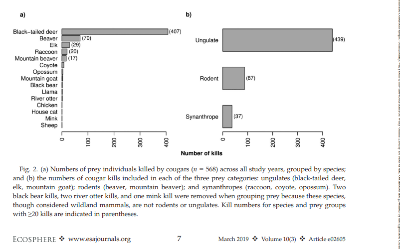
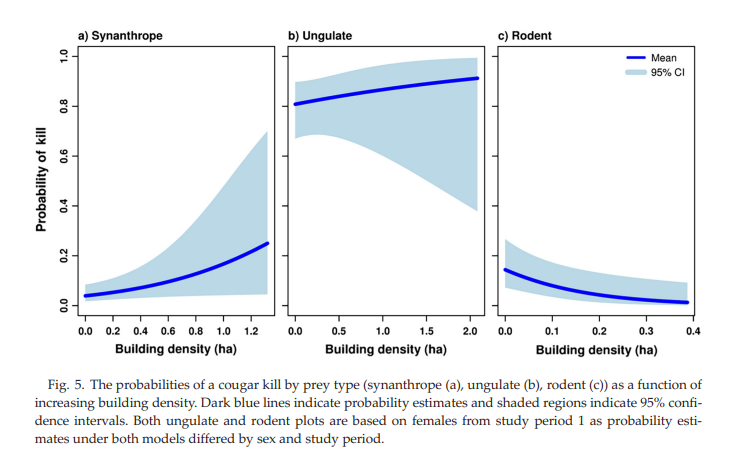
Results: Firstly synanthropic prey use increased and odds of cougars preying on synanthropes (animals living in close association with humans) rose nearly fivefold with each additional building per hectare. However, only certain individual cougars specialized in synanthropes. Black-tailed deer and elk did remain the dominant prey throughout. Cougars remained to rely on ungulates as prey, which suggests that predator-ungulate systems can survive near human settlements. Additionally, as building density increased, kills of beaver and mountain beaver decreased, likely due to habitat loss and management practices reducing rodent presence. And it was also discovered that male cougars hunted rodents more often than females. Lastly, the study showed that some cougars deviated extensively in prey choice. For example, one male accounted for half the rodent predation.

Criticisms: Overall I thought this study was an insightful and interesting read. The research did have some limitations however. For one, building density was the only measure of urbanization, which oversimplifies the the complexity of human disturbance. Furthermore, the difference in collar technology between study periods may also have affected kill detection, making temporal comparisons less reliable. The lack of direct data on prey abundance makes it difficult to analyze whether dietary preferences of the cougar was a result of prey preference or prey abundance. Lastly, the limited sample size of twenty cougars makes it hard to apply this data across populations. Individual variation most likely strongly influenced results, especially if one male accounted for half the rodent kills. Future work could benefit from combining prey availability survey with kill site data to distinguish between preference and availability. Additionally standardized tracking technology, multiple measurements of urbanization, and a broadened sample size would yield more thorough results.

Reference:

Robins, C. W., Kertson, B. N., Faulkner, J. R., & Wirsing, A. J. (2019). Effects of urbanization on cougar foraging ecology along the wildland–urban gradient of western Washington. Ecosphere, 10(3), e02605.https://esajournals.onlinelibrary.wiley.com/doi/10.1002/ecs2.2605

Bat Activity in an Urban Landscape: Patterns at the Landscape and Microhabitat Scale

Posted on

Overview

The article that I am reviewing is “Bat Activity in an Urban Landscape: Patterns at the Landscape and Microhabitat Scale” by Gehrt and Chelsvig (2003). This study addresses an important and often overlooked question in urban ecology: how do bats respond to increasing urbanization, and to what extent do both large-scale (landscape-level) and fine-scale (microhabitat) features influence their activity? Bats play a crucial ecological role as insect predators, yet research on their persistence in urban and suburban environments has historically lagged behind studies of more visible species.

The authors sought to answer two primary questions. First, they inquired about how landscape-scale variables, such as the proportion of forest cover or urban development, influence overall bat activity. Second, they examined whether microhabitat characteristics, including canopy cover, presence of water, and local vegetation structure, explain additional variation in bat activity beyond what can be predicted by landscape context alone. Together, these questions aimed to shed light on how bats navigate increasingly fragmented urban environments and what habitat elements are most critical for their persistence.

Methods

To investigate these questions, the researchers conducted acoustic surveys across multiple sites representing a gradient of urbanization. Ultrasonic bat detectors were used to record echolocation calls, which served as an index of bat activity. The study design incorporated two spatial scales of analysis. At the landscape scale, the researchers quantified features such as forest cover, urban development, and impervious surface area surrounding each site. At the microhabitat scale, they measured local site variables including canopy density, vegetation structure, and proximity to water.

Data collection took place during the summer months to coincide with peak bat activity. The researchers then analyzed bat “passes” (recorded calls) to determine how strongly activity correlated with both landscape and microhabitat variables, allowing them to separate broad-scale effects from those operating at the site level.

Results

The results revealed a clear pattern: bat activity declined as the amount of urban cover increased and was positively associated with forest cover. This suggests that bats are sensitive to habitat loss and fragmentation at the landscape level. However, the study also found that microhabitat features significantly influenced bat activity even within similarly urbanized areas. Sites with dense tree canopy, well-developed vegetation structure, and water sources exhibited higher activity than sites lacking these features.

These findings demonstrate that landscape context and local habitat quality interact to shape bat distributions. Two sites with comparable levels of urbanization could display markedly different levels of bat activity depending on their microhabitat composition. This means that conserving or restoring key habitat elements at the local scale can have a meaningful impact on maintaining bat populations even within urban settings.

Critiques and Reflection

This study is commendable for highlighting that both large-scale and fine-scale habitat features must be considered when developing urban wildlife management strategies. Its reliance on acoustic monitoring was also useful, as it provided a non-invasive yet comprehensive method for assessing bat presence and activity across numerous sites. Furthermore, the study’s findings carry clear implications for urban planning, suggesting that preserving forest patches, maintaining tree canopy, and protecting water bodies can promote bat activity in otherwise developed landscapes.

Nevertheless, there are areas in which the study could be strengthened. The analysis aggregates overall bat activity rather than distinguishing among species or foraging guilds, which may obscure species-specific responses to urbanization. Some species may be more tolerant of urban settings than others, and identifying these differences would help refine conservation priorities. Additionally, the study’s temporal scope is limited; sampling across multiple seasons or under varied environmental conditions could reveal whether the observed patterns are consistent year-round. Finally, the article could have offered explicit management recommendations, such as quantifiable targets for canopy cover or patch size, that would be useful for city planners and conservation practitioners.

Despite these limitations, the study contributes meaningfully to urban ecology by illustrating that microhabitat improvements can mitigate some of the negative effects of urbanization on bats. It challenges the notion that urban areas are inherently unsuitable for wildlife and underscores the importance of intentional habitat design in cities.

Reference

Gehrt, S.D. and Chelsvig, J.E. (2003), BAT ACTIVITY IN AN URBAN LANDSCAPE: PATTERNS AT THE LANDSCAPE AND MICROHABITAT SCALE. Ecological Applications, 13: 939-950. https://doi.org/10.1890/02-5188

Black Bear foraging behavior in urban landscapes

Posted on

Background:

Black bears require a very high caloric intake leading up to the cold months when hibernate. They depend on a decent yield of soft and hard mast production in order to reach these nutritional needs, but sometimes hard or soft mast yields may drop too low to sustain Black bear populations. When this happens, bears need to forage for alternate food sources. Urbanization has been rapidly increasing which alters what these Black bear populations are exposed to. Being highly adaptive creatures, Black bears have come to use human garbage as an alternate food source. For urban bears, garbage can be easily accessed and can be high in calories.

This study was conducted in order to understand their foraging ecology in urban landscapes. The goal of the research is to find better solutions to mitigate human-wildlife conflict with Black bears.

Methods:

This study was conducted in the urban areas of Aspen, Colorado. During the months of May-August, researchers captured bears and fitted them with radio collars that were programed to report the bear’s locations every 30 minutes between May-September. From 2007-2010, researchers tracked 40 bears during May-September, which is their active season in Colorado. They backtracked to bear locations then inspected the area to see whether there is evidence of natural or anthropogenic foraging evidence. The area they would search at each back-tracked location had a 20 meter radius. They remotely downloaded data and backtracked to the most recent 24 hours of location data. They did not backtrack to the most recent location in order to avoid disturbing the bears, and they only used locations that were within 50 meters of a building.

Natural foraging evidence included animal carcasses, broken foliage, turned over rocks, ect. Anthropogenic foraging evidence included scattered garbage, visual observations of people present, broken limbs on landscape trees, broken windows, ect.

They used the backtracking data to summarize spatial and temporal patterns of the bears on natural and anthropogenic food sources.

Results:

Prehyperphagia refers to the months of May-July. Hyperphagia is when bears greatly increase their food intake prior to winter, during the months of August-September. Garbage was by far the most highly used anthropogenic food source. While garbage was consumed in high amounts every year, the poor years (years when less natural food sources were available) accounted for much higher levels of garbage consumption. The amount of garbage consumed during Hyperphagia was 5 greater during poor years.

The researchers randomly sampled 384 garbage containers and found that 76% of them were bear-resistant, but only 57% of the bear-resistant containers were properly secured.

Discussion:

The researchers determined that Black bears are most driven by cost vs reward when foraging. They put in the least amount of effort for the highest amount of caloric intake. They determined that the best next action is to decrease the reward bears receive when foraging in garbage, or increase the amount of effort put in. That would hypothetically steer bears towards foraging in wild land areas more often.

Critiques and takeaways:

Overall, I found the methods of this study to be fairly reliable in reducing potential bias and effectively answering the research question. The researchers were able to analyze 2 good years and 2 bad years. They were able to follow a decent sample size of bears, and collect data from a high number of feeding locations. They did, however, not dive deep into the dynamics within the wild land areas surrounding Apen, Colorado. This makes sense since the purpose of this study was to find answers specific to urban Black bear foraging behavior. This does raise a couple of questions that could aid in the understanding of urban Black bear foraging behavior though. Mostly, I think it’s worth researching Black bear population dynamics in the surrounding wild areas. Are these urban bears only urban because they are being pushed out of natural spaces by more dominant bears? Is there a lack of food sources available to sustain the whole Black bear population in these areas? How does hunting or a lack thereof play into the need for bears to travel into urban areas? To what degree are Black bears bothered by entering urban areas, and how bad do the alternatives need to be to push them there?

Those are a lot of questions, but I think it would be very interesting to conduct research that could answer some of these questions in wild land locations surrounding Aspen, Colorado in order to best relate results to one another.

Article:

URL: https://esajournals.onlinelibrary.wiley.com/doi/full/10.1890/ES15-00137.1

Citation: Lewis, D. L., S. Baruch-Mordo, K. R. Wilson, S. W. Breck, J. S. Mao, and J. Broderick. 2015. Foraging ecology of black bears in urban environments: guidance for human-bear conflict mitigation. Ecosphere 6(8):141. http://dx.doi.org/10.1890/ES15-00137.1

Urban and Suburban Deer Management by State Wildlife-Conservation Agencies

Posted on

Overview

The title of the paper I will be reviewing is “Urban and Suburban Deer Management by State Wildlife-Conservation Agencies.” The primary reason this study was conducted is because of increasing populations of white-tailed deer in urban and suburban areas throughout the United States. Human-wildlife conflicts have increased as a result of this population growth, which has led to the implementation of various deer management strategies in urban areas. These strategies can either be lethal or nonlethal. Some examples of urban management strategies are bow hunting, firearm hunting, contraception, sharpshooting, trap-and-relocate, and trap-and-kill. There are significant amounts of data available regarding public opinion of various deer management methods in urban areas. However, there has been little effort to understand the management techniques that are preferred by wildlife biologists at state agencies. This study focused on two primary goals. The first of these was to determine what deer management techniques are currently being used by state conservation agencies, their perceived efficacy, and their legality. The second goal was to identify possible drivers for differences in opinions between deer biologists and the general public. 

Methods

The primary method of data collection used in this study was an online survey that was provided to deer biologists who worked at state wildlife agencies. The survey was sent to 41 different state agencies, and 34 of these agencies provided a response. The survey included 10 questions to be answered by deer biologists. These questions mainly focused on the management techniques currently being used in each state, their level of effectiveness, reasons for managing deer populations, and the legality of management techniques. 

Results

The results from this survey were informative for providing answers to the questions being answered by this study. The majority of states indicated that their urban/suburban deer populations were increasing, and the majority of deer biologists believed that urban/suburban deer populations were an issue in their state. One interesting finding was that 64.7% of deer biologists have not done any surveys of local communities regarding their opinions on urban/suburban deer management. The most popular and effective management techniques according to deer biologists were archery hunts, sharpshooting, and firearm hunts. The least popular methods according to deer biologists were trap-and-kill, contraception, sterilization, and trap-and-relocate. The legality of the previously mentioned methods is an influential factor for determining how much they are used in certain states. The vast majority of deer biologists indicated that the primary reasons for management of urban/suburban deer populations were deer-vehicle collisions and damage to gardens. Other popular reasons for management were native vegetation damage and agricultural damage due to deer populations. Additionally, 88.2% of states concluded that the current management of urban/suburban deer populations in their state was effective. 

Critiques/Reflection

This study was able to collect valuable information regarding the opinions of deer biologists on managing urban/suburban deer populations. Although deer biologists and the public commonly agree on the reasons for managing these deer populations (car collisions and garden damage), they have not been able to reach a consensus on the methods that should be implemented. The public is typically not heavily involved with decision making regarding urban deer management policies. This was shown in the survey results since 64.7% of state deer biologists have not made the effort to survey communities about their opinions on deer management. This study could be improved by asking an additional question relating to public opinions. Instead of simply asking if public opinion surveys had been conducted in each state, the questionnaire should have also asked for the reasoning behind this decision. If the state agencies chose not to involve public opinion when making decisions on urban/suburban deer management, then it would be valuable to know why this was the case. There could be a variety of reasons (lack of funds, lack of public interest, inability to reflect public opinion in policies, etc.) for not surveying public opinions, but this study does not provide data to answer this question.

Another suggestion to improve this study could be to modify the methods used for data collection. Overall, there was a high response rate to the survey that was sent to the state wildlife agencies. Although many of the agencies responded to the survey, increasing the amount of data collected would increase the reliability of the study’s findings. This study chose to send the survey in an email and then send a reminder email two weeks after the first email was delivered. I believe that choosing to send the reminder email was a beneficial idea, however, I think that this could be improved. Instead of solely communicating with the wildlife agencies through email, I think that the researchers should have made phone calls to the state wildlife agencies that had not responded to the survey. The agencies could have overlooked the email, or they may not have been certain about the legitimacy of the survey. By making a phone call to the agency, the researchers could have made a more personal connection to the deer biologists who work there. This could have led to higher response rates to the survey, which would have led to larger amounts of data being available to analyze for the study. 

Reference

Rachael E. Urbanek, et al. “Urban and Suburban Deer Management by State Wildlife-Conservation Agencies.” Wildlife Society Bulletin (2011-), vol. 35, no. 3, 2011, pp. 310–15. JSTOR, http://www.jstor.org/stable/wildsocibull2011.35.3.310. Accessed 11 Sept. 2025.

The Effects of Road Mortality on Small, Isolated Turtle Populations

Posted on

Background and Purpose: With an exponentially growing populations comes infrastructure, accompanied by roads. The direct and indirect effects of roads have been and will continue to be an important conservation concern for species that utilize a network of connected habitats. Most all taxa are affected by roads, however, herpetofauna, especially freshwater turtle species are disproportionately affected by additive adult mortality.  Being an already vulnerable species group with high juvenile mortality and high adult and subadult survivorship, anthropomorphic stressors, such as road mortality, are concerning. Roads not only act as a barrier of dispersal—effecting gene flow and changing animal behavior, but they are also the leading causes of death for some species. For turtle species, roads disproportionally effect nesting females who travel large distances across a landscape gradient—leading to a shift in sex ratios. Species like the Spotted Turtle who use a combination of wetlands and upland habitat across the landscape are more at jeopardy than wetland species that facilitate life processes in a single wetland. 

Study Species: Spotted Turtles are a small, freshwater wetland species that inhabit a variety of wetland types including vernal pools, bogs, marshes, roadside ditches, and small streams. With an expansive range from southern Canada to northern Florida, Spotted Turtles are found in many environments across the Atlantic Coast. They are declining across their range, however, due to a variety of environmental stressors including poaching, habitat fragmentation, wetland loss, road mortality, pollution, illegal trade, and many more. Spotted Turtles have a short active season, being in the water from March through June, and then aestivating and nesting during the summer months. They have large home ranges, especially nesting females—using the upland habitat bordering their wetlands as areas for nesting, short migration between wetlands, and aestivating. With an increase in urbanization, these upland habitats are being highly fragmented by roads—leading to high rates of road mortality. Although there is much said in the literature about the impacts of roads on turtles, there have been few examining the impact of road mortality on freshwater turtle populations. 

Methods and Results:  The study site was located in central Maryland with a paved, two-lane road intersecting it. The average number of vehicles driving on the road was 2017 to 2087 vehicles per days. North of the road were four ephemeral wetlands totaling 6.94 hectares in area. To the south were three permanent and one ephemeral wetland. Spotted Turtles were caught by hand and collapsible mesh minnow traps. All turtles were marked and measured. Both sides of the road (including the northern and southern wetland complexes) were treated as separate populations. PVA’s or population viability analyses were used to simulate Spotted Turtle population trajectories under baseline conditions with added road mortality.  

After running the models, both the northern and southern populations showed negative growth rates. Without road mortality, extinction risk is about 20-24% in 150 years, however, with road mortality, extinction risk is greater than 90%. Every slight increase in adult mortality increases the rate of extinction. While road mortality itself was only around a 2% loss annually, it is catastrophic for these small, isolated Spotted Turtle populations. 

Importance: There are large data gaps into what we know about Spotted Turtles, specifically in more robust populations where they are more abundant. This study is one of the first studies to attempt to quantify the direct effects that roads have on freshwater turtle viability. Although Spotted Turtles suffer from a variety of environmental stressors as mentioned before, road mortality can dramatically reduce population viability.  Many of the isolated areas Spotted Turtles inhabit are now being affected by urban sprawl and increasing infrastructure. These once remote upland area are now surrounded by neighborhoods, and many of these wetland complexes have been segmented by roads. There have been other studies looking at road mortality on freshwater turtle populations but depending on the species and the current status and structure of their populations, even large starting populations may have high extinction probabilities. 

Future Work: In North Carolina, road mortality appears to be especially high in areas like the inner/outer banks where Spotted Turtle populations are more robust. In my research, I have noticed that rural areas with multiple wetland complexes seem to result in high road mortality rates in Spotted Turtles. Although these areas are not city centers, and you may not even consider them urban, the infrastructure necessary to support growing populations is there. Studies like these should be replicated across Spotted Turtles’ range. Given that these turtles inhabit such a broad variety of ecosystems, the replication of this study in more southern populations is pivotal. Slight differences in behavior across populations may yield different results related to road mortality. In North Carolina, our populations are more active during the Spring months, and towards the end of May females will begin traveling to nest. For some wetland species, like the Spotted Salamander, that make great migrations once a year to reproduce, people have collaborated with local departments of transportation to aid in these mass movements during the winter months. Although it may not be as realistic for Spotted Turtles, there are ways to mitigate road mortality. Because Spotted Turtles are considered a species of concern in some places across the United States and are listed as endangered through the IUCN, you would have to be careful not to reveal the exact locations of these populations due to poaching. Progress is currently being made to increase the detection of Spotted Turtles across their range through a Competitive State Wildlife Grant funded by USFWS. By increasing the amount of data we have on Spotted Turtles in general, we can make informed conservation decisions regarding road mortality and other stressors threatening their status. 

Reference: Howell, H. J., & Seigel, R. A. (2019). The effects of road mortality on small, isolated turtle populations. Journal of Herpetology, 53(1), 39–46. https://doi.org/10.1670/18-022

THE INTEGRATION OF REMOTE SENSING AND GEOGRAPHIC INFORMATION SYSTEM (GIS) IN MANAGING URBAN ECOSYSTEMS

Posted on

Background and Purpose:
The purpose of this study was to evaluate the effectiveness of remote sensing and GIS to manage urban ecosystems. The study takes place in West Africa which is a region that is experiencing high rates of urbanization. These two types of software can be used as a way to visualize and predict spatial features such as landscape, vegetation cover, water bodies, and human settlements as they change over time.

Methods:
The study analyzes three sites along the Ivory Coast: Abidjan, Accra, and Lagos. Image data from Google Earth Engine and USGS Earthexplorer were obtained. The image data were then analyzed to determine the Built-Up Index (permeable surfaces), Normalized Difference Vegetation Index, and Normalized Difference Water Index.

Results and Discussion:
The final results of the study were maps generated through remote sensing and GIS data that compare the three indexes mentioned in the paragraph above. The discussion highlighted that an increase in the Built-Up Index leads to a decrease in the other two indexes which points to negative effects from urban areas. The study then reiterates the usefulness in using GIS and remote sensing to create management plans for urban ecosystems.

Reasons for Selecting:

I have an interest in GIS and the data science aspect of ecology. I saw this study was fairly recent and involved something relevant to the class as well as my personal interest. I have some background knowledge of GIS and remote sensing but I wanted to learn more about new methods and how this topic specifically relates to urban wildlife management.

Critiques:

My initial thought was that this study was fairly short. Each of the sections were only a few paragraphs long and the bulk of the article’s length was taken up by images and references. The results and discussion were combined into one section that was less than a third of a page long. I would have liked to see more in depth explanations of each section. Also, the study didn’t seem like it discovered anything new or exciting. They just selected data that they wanted to represent and plugged it into ArcGIS. To me, it appeared that they were more so demonstrating what the software that can be used for rather than a new method.

References:

Oppong, J., Ning, Z. H., Twumasi, Y., Antwi, R. A., Anokye, M., Ahoma, G., Annan, J., Namwamba, J. B., Loh, P., and Akinrinwoye, C.: THE INTEGRATION OF REMOTE SENSING AND GEOGRAPHIC INFORMATION SYSTEM (GIS) IN MANAGING URBAN ECOSYSTEMS, Int. Arch. Photogramm. Remote Sens. Spatial Inf. Sci., XLVIII-M-3-2023, 169–175, https://doi.org/10.5194/isprs-archives-XLVIII-M-3-2023-169-2023, 2023.

How to add a blog post

Posted on
  1. Go to Moodle main page and click on the link for “Current Class Blog”. 
  2. You will see a screen below and then log in to WordPress using your NCSU account.

3. Once you logged in, you should be able to see WordPress below. Then click on “+ New” to add a new blog.

4. Next, you can edit the contents for your blog and choose a category on the right-bottom corner. There are two categories for you to choose, either a Class Discussion Report (the reflection blog post) or Critical Review.

5. Rember to click “Publish” on the right-up corner and check the class blog again if it works.

PS: you can also access the class blog through WolfWare. Right next to the “Moodle” icon, click “WordPress” and the rest is the same as instructed.

Welcome to the class blog

Posted on

This is where you will be posting your three critical review blogs.

  • For any topic relevant to urban wildlife, find a peer-reviewed research
    paper that interests you. Write an essay for the class blog with your
    critical own reflections on the paper.
  • You could write about what could be improved in the data analysis,
    what additional variables should be considered, how the discussion of
    findings can be improved, what are future research directions, what
    you might have done differently, and why this paper caught your
    attention, or other related thoughts.
  • here will be writing workshops during class and students will work on
    their blog and discuss it in a group.
  • The blog posts will be due on 1. September 17th, October 15th, and November 12th.