Use of eDNA in Identifying Seasonal Variation in Urban Mammal Diversity

Posted on

Overview

Urbanization is rapidly increasing and reshaping how mammals move through fragmented landscapes. As cities expand, habitat connectivity declines, and seasonal changes in food availability may further influence species activity and behavior. This study uses environmental DNA (eDNA) to examine whether urban mammal communities show seasonal variation across Detroit, Michigan. I chose this article as it investigates a novel approach for detecting mammals in urban green spaces.

Methods

Soil samples were collected from 21 urban parks in Detroit. Because this method is non-invasive and minimally disruptive, no collection permits were required. These same parks are also part of a long-term camera trap monitoring project. Sampling took place in February and July 2023, representing the winter and summer seasons. Up to four soil samples were collected per park, yielding 33 winter and 32 summer samples for a total of 65. Each sample consisted of approximately 200mL of soil collected within a four-meter radius around focal trees where camera traps were placed. Both topsoil and subsurface layers were sampled. Shoe coverings were worn between sites, and all equipment was sterilized with bleach to prevent contamination. Samples were refrigerated prior to DNA extraction.

DNA was extracted from the 65 soil samples in triplicate, resulting in 195 total extractions, using the Qiagen DNeasy PowerSoil Pro Kit. The MiMammal-U primer set was used to amplify a ~170 base pair fragment of the 12S rRNA gene. Negative controls were included to monitor contamination. Sequencing was performed on an Illumina NovaSeq 6000 platform at the Yale Center for Genome Analysis.

Results

Of the 195 eDNA extractions, 176 successfully yielded DNA sequences identifying 23 mammal species, including humans. Sampling coverage reached 96 percent, indicating strong representation of the mammal community. Human DNA was detected in 58 of the 65 sites, meaning it was present in every park. Domestic species were common, with dogs detected in 10 parks and cats in 13. Pig and cattle DNA were also found across multiple sites, likely the result of food waste or fecal contamination.

Table 1. Mammal species detected at Detroit Parks via eDNA and iNaturalist observations.

Seasonal patterns were evident. In winter, brown rats, pigs, and unidentified Rodentia sequences were detected, while in summer, groundhogs, striped skunks, and muskrats were identified. Species richness varied across parks, ranging from two species at Butzel Playfield, a small 1.7-hectare park, to 14 species at Eliza Howell Park, a 101.2-hectare park that forms part of a wildlife corridor with Rouge Park. Despite these variations, paired comparisons of winter and summer samples showed no significant seasonal differences in alpha diversity (species richness), and ordination analyses (nMDS) revealed low community dissimilarity between seasons.

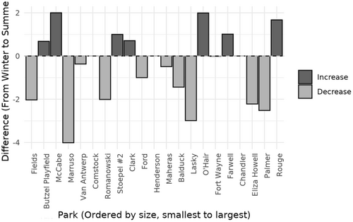
Changes in seasonal species richness detected across the 21 park sites using eDNA.

Discussion

Monitoring urban wildlife is increasingly important as cities expand and environmental changes alter habitat quality and animal behavior. While eDNA proved effective in detecting a wide range of urban mammals, results suggest that seasonal variation in species richness is minimal within Detroit’s parks. Subtle differences in species presence may reflect behavioral or dietary shifts rather than major community turnover.

Reflection and Critiques

Although this study provides valuable insight into urban mammal diversity and seasonal dynamics, I think several limitations should be acknowledged. Data was collected during a single annual cycle, limiting the ability to account for interannual variability in weather conditions or resource availability. While eDNA offers strong detection for cryptic or elusive species, camera traps may be more cost-effective and reliable for monitoring visible, easily identifiable mammals. Future research combining eDNA and camera trap data across multiple years could provide a more comprehensive understanding of long-term seasonal and environmental trends in urban mammal communities.

Reference

Hallam, J., & Harris, N. C. (2025). Network dynamics revealed from eDNA highlight seasonal variation in urban mammal communities. Journal of Animal Ecology, 94(8), 1587-1602. https://doi.org/10.1111/1365-2656.70082

Urban Wildlife Connectivity and Habitat Conservation: Species of Conservation Concern in Michigan, USA

Posted on

Overview

I chose this article as it relates to urban wildlife management in the context of urban planning and optimizing cities for wildlife diversity and connectivity. The study focuses on locally rare species representing a wide range of taxa, offering insights into how urban areas can be designed to support biodiversity through habitat corridors. The authors evaluated patterns of habitat availability and connectivity for nine rare species: two insects, three turtles, two snakes, one bird, and one bat across four urban regions in Michigan, USA. These species were selected because they are regionally rare (ranging from state-listed to federally endangered) but still maintain populations within urbanized landscapes. The study aims to identify how urbanization influences habitat structure, connectivity, and opportunities for conservation planning.

Methods

The researchers selected nine focal species representing several taxonomic groups known to be regionally rare. Species occurrence data were compiled from multiple reputable databases, including the Michigan Natural Heritage Database (MNFI), the U.S. Fish & Wildlife Service (USFWS), HerpMapper, iNaturalist, and eBird. To ensure data reliability, only verified MNFI and Research Grade iNaturalist records were used, and records prior to the year 2000 were excluded. Protected areas were mapped by merging all federal, state, county, local, and NGO-managed lands from MNFI GIS layers, excluding disturbed greenspaces such as golf courses.

Urban boundaries were defined using U.S. Census Bureau criteria areas with populations over 50,000 and a density of at least 1,000 people per square mile, with adjacent tracts of 500 people per square mile included as urban periphery. This classification allowed the researchers to analyze habitats embedded within realistic urban-to-rural gradients. Connectivity analyses were then conducted within selected urban regions that met these demographic criteria and contained overlapping species occurrences.

To establish biologically relevant study sites, the team generated 5 km buffers around each species occurrence, encompassing estimated dispersal ranges for most taxa. Overlapping buffers within 10 km of each other were merged, and convex hull polygons were created around the merged clusters. These polygons were then expanded by 5 km to define final analysis areas representing zones of multi-species co-occurrence. This ensured that the study captured both urban and adjacent non-urban habitats crucial for species movement.

Species distribution models (SDMs) were developed for each focal species using an “ensemble of small models” (ESM) approach, which performs well with limited occurrence data. Occurrence points were spatially thinned to a minimum spacing of 1 km to prevent overrepresentation of dense populations, with a target of at least 20 records per species. In cases of limited data, such as the American Bumble Bee, surrogate models were used (the Black and Gold Bumble Bee model).

Road networks were not included in the SDMs directly to avoid false habitat associations, but they were incorporated into resistance surfaces used for connectivity modeling. Roads were buffered by 30 m and assigned species-specific cost values to represent movement resistance: 1000 for reptiles (reflecting high road mortality), 500 for birds and bats (behavioral avoidance), and 250 for bees (potential roadside habitat but increased mortality risk). These road-cost rasters were then merged with each species’ SDM-based resistance surface.

Connectivity was evaluated using multiple tools. Circuitscape was applied to identify likely movement corridors and high-current areas representing multi-directional pathways, while Graphab was used to analyze habitat patch importance and network structure through the dPCk metric. Fragstats provided quantitative measures of landscape configuration, including connectance and clumpiness. Together, these tools revealed both broad and fine-scale patterns of connectivity and potential barriers for each species within and around the urban zones.

Results

Findings showed that many species retain moderate to high habitat proportions within urban landscapes, but the strongest connectivity corridors are typically located outside urban boundaries. Riparian and wetland zones were identified as critical linkages, especially for aquatic and semi-aquatic species such as turtles and snakes. Among the cities, Kalamazoo and Detroit North exhibited the most extensive multi-species connectivity networks, while Benton Harbor and Detroit Southwest showed more limited urban movement potential. Turtles had the highest habitat availability overall, suggesting persistent wetland and forest-edge habitats, whereas grassland species like Henslow’s Sparrow and bumble bees had the least. The study also emphasized that smaller, well-placed habitat patches often contribute more to overall connectivity than larger, isolated ones.

Fig. 3. Map of study area (a) showing Least Cost Paths (LCP’s), (From left to right) Protected areas, barriers impeding connectivity, and current species density.

Critiques & Reflection

This study effectively demonstrates how integrating multiple connectivity modeling tools can inform urban conservation planning. The inclusion of diverse taxa from reptiles to insects gives the findings broad ecological relevance. I found it particularly valuable how the authors linked quantitative spatial analysis to practical conservation implications, such as protecting riparian corridors and small but strategically located habitat patches.

The article does a great job of emphasizing the importance of riparian corridors and buffers, which in my opinion are not adequately regulated under today’s environmental laws. These areas are critical for maintaining ecological connectivity in urban regions, yet they are often overlooked in planning and development regulations.

Although the paper briefly mentions genetics, I believe this is an area that deserves greater focus. Genetic diversity and gene flow are essential components of wildlife corridor restoration, especially for populations that have become isolated by urbanization and experienced bottlenecking. Wildlife corridors are not only about providing safe passage between fragmented habitats,  they also serve as vital habitat themselves, supporting long-term survival, breeding, and dispersal. Many isolated reptile populations, for instance, have not experienced genetic connectivity for centuries due to habitat fragmentation. Snakes are particularly vulnerable to urbanization and the lack of corridors, as they are frequently forced to cross roads where they face high mortality rates, often being killed by vehicles, sometimes even intentionally, despite their protected status.

Despite these challenges, the approach presented in this study offers a replicable framework for urban planners seeking to incorporate biodiversity goals into development strategies. It highlights that even within heavily modified landscapes, thoughtful urban design and targeted protection efforts can sustain rare species populations and maintain ecological connectivity.

Reference

McCluskey, E. M., Kuzma, F. C., Enander, H. D., Cole-Wick, A., Coury, M., Cuthrell, D. L., Johnson, C., Kelso, M., Lee, Y. M., Methner, D., Rowe, L., Swinehart, A., & Moore, J. A. (2024). Assessing habitat connectivity of rare species to inform urban conservation planning. Ecology and Evolution14(3), e11105. https://doi.org/10.1002/ece3.11105

Managing an Urban Landscape with Pollinators in Mind

Posted on

Overview

The article I reviewed is Enhancing pollination supply in an urban ecosystem through landscape modifications by Davis et al. (2017), published in Landscape and Urban Planning. As urban farming becomes more common, understanding how to support pollinators in cities is increasingly important. This study examines whether converting small portions of turf grass into flowering habitat could increase pollinator supply and benefit urban agriculture. The researchers used Chicago, Illinois, as their study area and focused on modeling how different strategies for increasing floral resources, such as planting flowers in city parks, residential yards, or near community gardens, would impact pollination availability. The goal was to help city planners and residents find the most effective way to support pollinators and improve crop yields in urban gardens.

Methods

The researchers first mapped the locations of urban farms, community gardens, and home food gardens using Google Earth imagery. They then collected pollinator specimens from 15 community gardens across Chicago using colored pan traps filled with a detergent solution. Traps were arranged in a 3 x 3 meter grid, spaced one meter apart, with alternating colors, and left out for one daylight cycle each month during July, August, and September 2009.

Specimens were preserved in ethanol and later identified to genus or species. Using this field data, the team validated the InVEST pollination model, which uses land cover, nesting resources, and floral resources to predict pollinator abundance. They then modeled several scenarios simulating the conversion of one to five percent of Chicago’s turf grass to pollinator-friendly flower gardens in different locations, including city parks, private yards, and areas within varying distances of community gardens, to compare how each strategy affected pollination supply across the city.

Results

The study found that augmenting floral resources can increase pollination supply in Chicago, but the most effective strategy depends on the type of urban agriculture. For home gardens, distributing flowers throughout the city was most beneficial, while concentrating flowers near community gardens and urban farms provided the greatest pollination benefits for those larger sites. The InVEST model predicted 46 percent of the variation in native bee richness, indicating that it can reliably identify areas with high or low pollination potential. The results highlight that city parks, forest preserves, and green spaces act as pollination hotspots, whereas downtown and heavily industrialized areas may have lower pollination supply.

Fig. 1. Study area (Chicago, Illinois)with inset of United States.

Fig. 2. Map of pollination supply score and location of sites used for model validation, i.e. sites where bees were collected.

Fig. 4. Effect of landscape modification scenarios on pollination supply scores.

Critiques and Reflection

While this article provides valuable insight into the role of bees in urban pollination and demonstrates how modifying turf grass can enhance pollinator supply for both residential and commercial agriculture, it has some limitations. One notable omission is the lack of consideration for other important insect orders, such as Diptera (flies) and Lepidoptera (butterflies and moths), which also play critical roles in pollination. Including these groups could provide a more complete understanding of urban pollinator communities.

The study excels in highlighting the underutilized potential of urban green spaces, particularly turf grass and ornamental plantings, and shows how thoughtful landscape modifications can provide both ecological and economic benefits. However, greater attention could be given to the use of native plantings, which not only offer nectar resources but also serve as host plants for pollinators, contributing to the restoration of urban biodiversity and supporting the life cycles of native insects.

Despite these limitations, the article provides strong empirical evidence for the importance of maximizing the ecological value of urban green spaces. It demonstrates that targeted interventions, such as converting portions of turf grass to flower gardens, can meaningfully enhance pollinator populations and improve urban agricultural productivity, making it a valuable resource for both researchers and urban planners.

Reference 

Amélie Y. Davis, Eric V. Lonsdorf, Cliff R. Shierk, Kevin C. Matteson, John R. Taylor, Sarah T. Lovell, Emily S. Minor. (2017). Enhancing pollination supply in an urban ecosystem through landscape modifications, 162, 157-166. https://doi.org/10.1016/j.landurbplan.2017.02.011